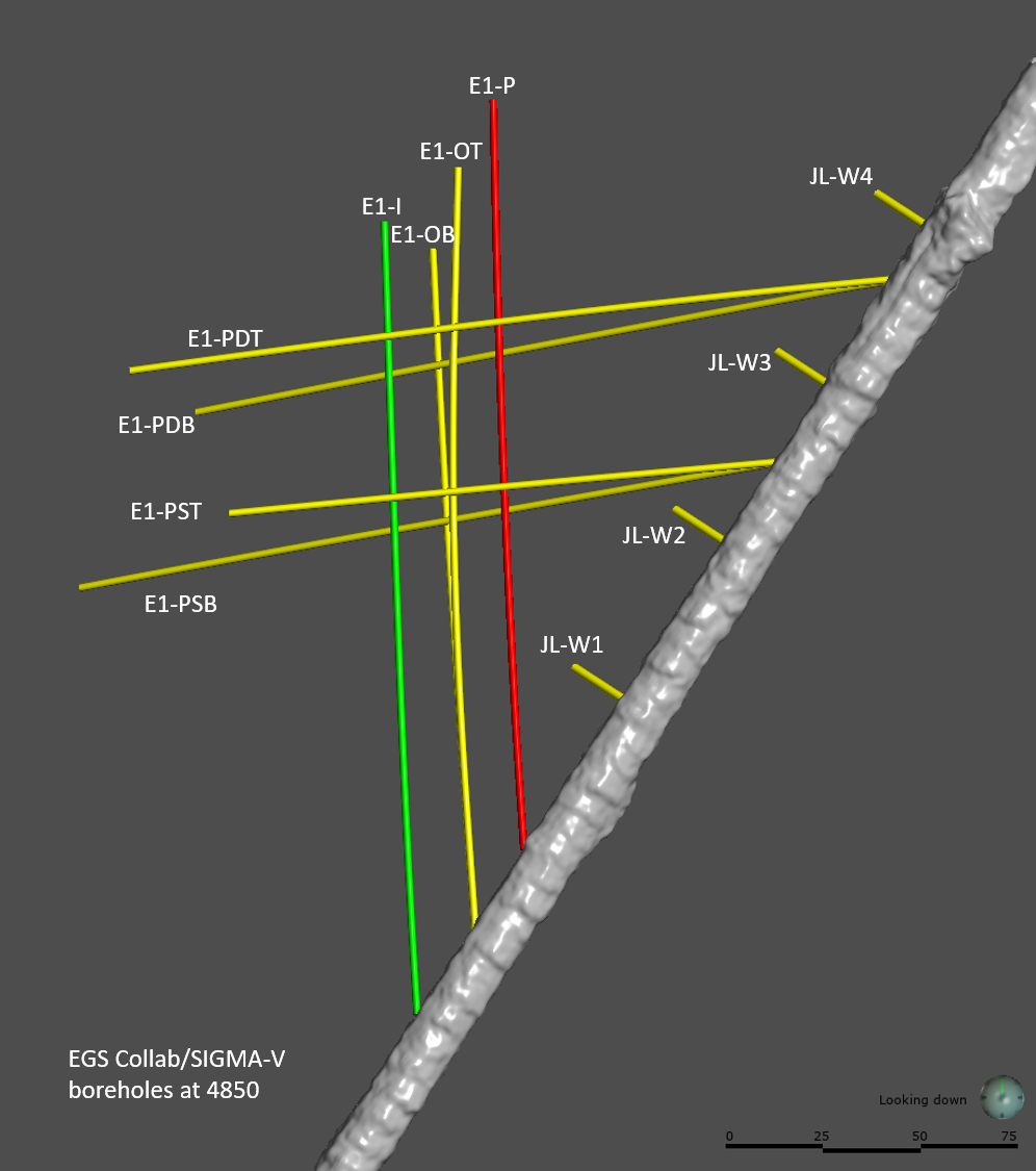
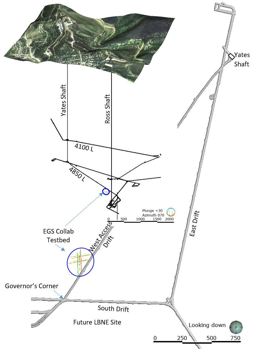
EGS Collab Experiment 1: Well Locations and Orientations.

The EGS Collab is conducting experiments in hydraulic fracturing at a depth of 1.5 km in the Sanford Underground Research Facility (SURF) on the 4850 Level. A total of eight ~60m-long subhorizontal boreholes were drilled at that depth on the western rib of the West Access Drift. Six of these holes are used for geophysical monitoring, one is used for hydraulic fracturing and the remaining hole was designed as a production borehole. In addition to these eight boreholes, 4 5-m Jack leg boreholes were drilled for housing geophones. This submission package includes well head locations, total lengths of boreholes, their orientations (gyro data). The reported boreholes orientation data were primarily obtained with REFLEX GYRO (TM) survey right after the completion of each hole. Gyro based orientations were later verified and refined with the results of magnetic orientation survey. Well head locations were ascertained by Laser/Lider survey of the drift around the Testbed.
Citation Formats
TY  - DATA
AB  - The EGS Collab is conducting experiments in hydraulic fracturing at a depth of 1.5 km in the Sanford Underground Research Facility (SURF) on the 4850 Level. A total of eight ~60m-long subhorizontal boreholes were drilled at that depth on the western rib of the West Access Drift. Six of these holes are used for geophysical monitoring, one is used for hydraulic fracturing and the remaining hole was designed as a production borehole. In addition to these eight boreholes, 4 5-m  Jack leg boreholes were drilled for housing geophones. This submission package includes well head locations, total lengths of boreholes, their orientations (gyro data). The reported boreholes orientation data were primarily obtained with REFLEX GYRO (TM) survey right after the completion of each hole. Gyro based orientations were later verified and refined with the results of magnetic orientation survey. Well head locations were ascertained by Laser/Lider survey of the drift around the Testbed.
AU  - Neupane, Ghanashyam
A2  - Ulrich, Craig
A3  - Roggenthen, William
A4  - Team, EGS Collab
DB  - Open Energy Data Initiative (OEDI)
DP  - Open EI | National Laboratory of the Rockies
DO  - 10.15121/1576950
KW  - geothermal
KW  - energy
KW  - EGS Collab
KW  - SIGMA-V
KW  - SURF
KW  - well location
KW  - EGS
KW  - stimulation
KW  - hydraulic
KW  - fracturing
KW  - Testbed 1
KW  - West access Drift
KW  - Sanford Underground Research Facility
KW  - boreholes
KW  - geophysical monitoring
KW  - Reflex gyro
KW  - orientations
KW  - Laser/lider
KW  - magnetic orientation survey
LA  - English
DA  - 2018/09/05
PY  - 2018
PB  - Idaho National Laboratory
T1  - EGS Collab Experiment 1: Well Locations and Orientations.
UR  - https://doi.org/10.15121/1576950
ER  -
Neupane, Ghanashyam, et al. EGS Collab Experiment 1: Well Locations and Orientations.. Idaho National Laboratory, 5 September, 2018, GDR. https://doi.org/10.15121/1576950.
Neupane, G., Ulrich, C., Roggenthen, W., & Team, E. (2018). EGS Collab Experiment 1: Well Locations and Orientations.. [Data set]. GDR. Idaho National Laboratory. https://doi.org/10.15121/1576950
Neupane, Ghanashyam, Craig Ulrich, William Roggenthen, and EGS Collab Team. EGS Collab Experiment 1: Well Locations and Orientations.. Idaho National Laboratory, September, 5, 2018. Distributed by GDR. https://doi.org/10.15121/1576950
@misc{OEDI_Dataset_7318,
title = {EGS Collab Experiment 1: Well Locations and Orientations.},
author = {Neupane, Ghanashyam and Ulrich, Craig and Roggenthen, William and Team, EGS Collab},
abstractNote = {The EGS Collab is conducting experiments in hydraulic fracturing at a depth of 1.5 km in the Sanford Underground Research Facility (SURF) on the 4850 Level. A total of eight ~60m-long subhorizontal boreholes were drilled at that depth on the western rib of the West Access Drift. Six of these holes are used for geophysical monitoring, one is used for hydraulic fracturing and the remaining hole was designed as a production borehole. In addition to these eight boreholes, 4 5-m  Jack leg boreholes were drilled for housing geophones. This submission package includes well head locations, total lengths of boreholes, their orientations (gyro data). The reported boreholes orientation data were primarily obtained with REFLEX GYRO (TM) survey right after the completion of each hole. Gyro based orientations were later verified and refined with the results of magnetic orientation survey. Well head locations were ascertained by Laser/Lider survey of the drift around the Testbed.},
url = {https://gdr.openei.org/submissions/1184},
year = {2018},
howpublished = {GDR, Idaho National Laboratory, https://doi.org/10.15121/1576950},
note = {Accessed: 2026-01-25},
doi = {10.15121/1576950}
}
https://dx.doi.org/10.15121/1576950
Details
Data from Sep 5, 2018
Last updated Oct 19, 2023
Submitted Nov 12, 2019
Organization
Idaho National Laboratory
Contact
Ghanashyam Neupane
208.526.6808
Authors
Original Source
https://gdr.openei.org/submissions/1184Research Areas
Keywords
geothermal, energy, EGS Collab, SIGMA-V, SURF, well location, EGS, stimulation, hydraulic, fracturing, Testbed 1, West access Drift, Sanford Underground Research Facility, boreholes, geophysical monitoring, Reflex gyro, orientations, Laser/lider, magnetic orientation surveyDOE Project Details
Project Name EGS Collab
Project Lead Lauren Boyd
Project Number EE0032708